Cuba

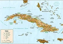
A general map of Cuba
Cuba is an archipelago of islands located in the northern Caribbean Sea at the confluence with the Gulf of Mexico and the Atlantic Ocean. It lies between latitudes 19° and 24°N, and longitudes 74° and 85°W. The United States lies 150 kilometers (93 miles) across the Straits of Florida to the north and northwest (to the closest tip of Key West, Florida), and the Bahamas 21 km (13 mi) to the north. Mexico lies 210 kilometers (130 miles) across the Yucatán Channel to the west (to the closest tip of Cabo Catoche in the State of Quintana Roo).
With the entire island south of the Tropic of Cancer, the local climate is tropical, moderated by northeasterly trade winds that blow year-round. The temperature is also shaped by the Caribbean current, which brings in warm water from the equator. This makes the climate of Cuba warmer than that of Hong Kong, which is at around the same latitude as Cuba but has a subtropical rather than a tropical climate. In general (with local variations), there is a drier season from November to April, and a rainier season from May to October. The average temperature is 21 °C (69.8 °F) in January and 27 °C (80.6 °F) in July.
Administrative divisions
Main articles: Provinces of Cuba and Municipalities of Cuba
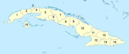
The country is subdivided into 15 provinces and one special municipality (Isla de la Juventud). These were formerly part of six larger historical provinces: Pinar del Río, Habana, Matanzas, Las Villas, Camagüey and Oriente. The present subdivisions closely resemble those of the Spanish military provinces during the Cuban Wars of Independence, when the most troublesome areas were subdivided. The provinces are divided into municipalities.
Provinces of Cuba


